The 2022 Summer
Outlook Report
Winter 2021-22 Recap
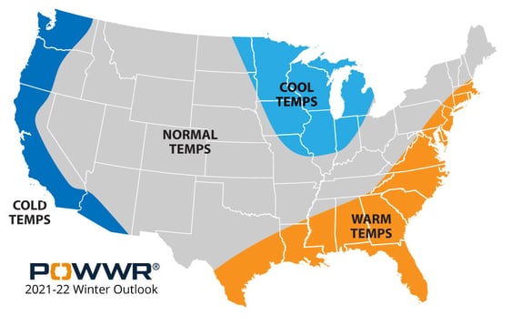
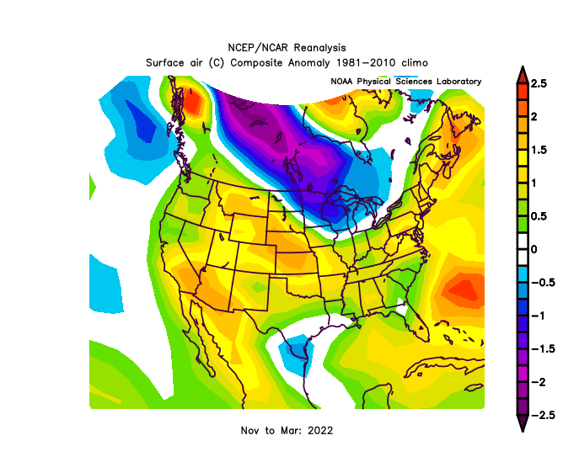
Back in October 2021, we called for Winter conditions as seen in Figure 1, with cold anomalies on the West Coast, cool anomalies in the northern Plains and western Midwest, and warm anomalies stretching from Texas, along the Gulf Coast, and up the East Coast into New England. As you can see from the NOV-MAR actuals displayed in Figure 2, our forecast actualized rather well save for the West, where it actualized warmer than we expected.
Figure 1

Figure 2

Summer 2022 Investigation
Soil Moisture
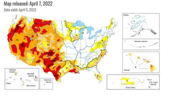
Currently (Figure 3), soil moisture is lacking for a good part of the United States, especially west of the Mississippi River.
For the most part, this area is under “severe” drought conditions which means more frequent and continual precipitation is required to alleviate the situation. Typically, winter rains provide the best opportunities for the slow, drenching rains to occur.
Spring rains tend to be heavy, violent, and contribute more to runoff (and lake-filling) than they do to deep soil moisture replenishment. As of now, this spring has been rather dry west of the Mississippi. I’m not saying that we have no chance to alleviate any of the drought before summer. If you recall, Spring 2021 started dry and turned rather wet (especially for Texas) into May and June. We will just have to wait and see. However, if the May/June rains don’t occur, I believe the lack of soil moisture will exacerbate the effects of any heat ridges that will occur.
East of the Mississippi, the only real trouble spot is Louisiana, especially south Louisiana. Other than that, the majority of the Midwest and eastern half of the U.S. is in decent shape. Any lack of soil moisture can be alleviated with a good shower or two.
Figure 3

The Southern Oscillation
Most people know the Southern Oscillation by its two manifestations, El Nino and La Nina. As many of you may recall from previous outlooks, El Nino and La Nina are different sides of the same coin. They both reflect anomalous water temperatures in the tropical Pacific Ocean. Currently, and since Fall 2020, we have been in a La Nina situation. Climate models predict this Nina to last through summer. Anomalous Pacific Ocean water temperatures have a large impact on the overall flow pattern of the atmosphere, especially the various jet streams. It is through this “general circulation” influence that our weather and temperatures are affected.
The 2022 Summer Outlook
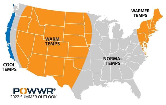
With a dearth of soil moisture west of the Mississippi and a La Nina-influenced general circulation pattern, we present our 2022 Summer Outlook (Figure 4). We are calling for the current drought conditions in the West, Intermountain West, and Plains to exacerbate the summer heat anomalies. This is similar to what actualized during summer 2021, where much of the western US saw early heat that stayed for the duration of the season.
We expect much of the Midwest and Southeast to be normal, with slight warm anomalies in the Northeast. Based on Summer 2021 (a similar climate set-up to Summer 2022), the main risk to our outlook is in Texas. Although we are calling for predominantly warm anomalies, in part based on the current extreme drought conditions, if May and June see adequate rainfall (as was seen in those months of 2021), the projected warm anomalies will not actualize to the expected level.
In the Tropics, we expect 19 named storms, 8 to reach hurricane strength, and 4 major hurricanes (cat 3 or greater). As for landfall, the more recent analog years are showing generally equal chances among Texas, the central Gulf, Florida, and the East Coast. If I go back a little further in time, those analogs give more of a landfall edge to Florida and the East Coast.
Figure 4

__________________________________________________
NOTE: POWWR provides this information as a courtesy to enhance the risk management process and are not responsible for the accuracy of this forecast and/or actions taken as a result of this forecast information.
__________________________________________________

Ian Palao
VP, Strategic Energy Services
Mr. Palao specializes in commodity risk management and the science of meteorology/climatology. He serves as one of POWWR’s many subject matter experts. He has 20 years of experience in the energy/utility industry where he used his skills and knowledge of meteorology and advanced statistics. From 2000 through 2011, he worked at TXU Energy Trading/Luminant Energy in Dallas where he served in three capacities. Most recently, he served as Capital/Liquidity Manager of the trading portfolio, optimizing the use of capital while still maintaining profitability. Prior to that, he managed the Weather Derivatives trading desk, devising strategies and executing trades for both speculative and hedging purposes. Upon joining TXU, he served as manager of the Quantitative Risk Group, assisting the company in the identification, quantification, and remediation of financial risks inherent in the company’s multi-commodity trading portfolio. In his first foray into energy/utilities, he was a Marketing Executive with Louisiana Gas Service Company, a local distribution company, where he primarily marketed natural gas technology to commercial and industrial customers. Before that, he served as a Research Scientist under contract to the National Oceanic and Atmospheric Administration (NOAA). Mr. Palao has an M.B.A. from Tulane University. He also has both an MS and BS in Meteorology from Florida State University. He is a member of the Financial Risk Management Committee of the American Meteorological Society (AMS).

Introducing: A better way to avoid costly errors in the day-ahead markets…
Probabilistic Forecast
Now you can use historic weather variables based on weather forecast and develop detailed weather deltas. Overlap delta’s on current short term forecast to get expected weather delta distribution.
- Stop guessing – base your decisions on quantifiable data.
- Have greater confidence during an extreme weather event.
- Complete and seamless package with your weather responsive forecast, our extreme weather scenario forecast, and now our probabilistic load forecast.
Also New:
ERCOT System Load Forecast

Because you deserve greater reliability when it matters most… NOW
ERCOT’s day ahead load forecasts have a reputation for big misses, but your business doesn’t have the luxury of absorbing these inaccuracies. POWWR’s new proprietary ERCOT system load forecast provides the reliability you need to make better day ahead decisions.

- Takes in weather actuals
- More efficient short term hedging, especially when prices are vulnerable to increases
- Get the jump on the competition with earlier and accurate pricing Greater peace of mind
Share this
You May Also Like
These Related Stories

2022-23 Winter Outlook Report

2024 Summer Outlook Report


